The Brook Restoration project includes planning a wetland system in the Mott Haven neighborhood of the South Bronx with native plantings to support fauna, similar to the natural brook that ran through the park in the late 1800’s. 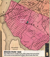 Rainwater harvesting from adjacent buildings will be divert 1,000,000 gallons of water a year from the combined-sewer to an above ground cistern for irrigation, and below-grade cisterns used to maintain water levels in the wetland. A comprehensive ecosystem assessment will be used to determine native plantings and diverse species habitat. Community involvement and stewardship will ensure the success of the project over the long-term.
Our South Bronx community needs and wants more green and aquatic open space to provide a more natural landscape. 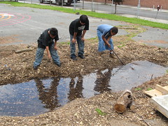 The Friends of Brook Park with the wider local community has had many discussions, meetings, and design sessions, as well as made presentations to solicit input and involvement in a grass-roots vision for the redesign of the asphalt portion of the park, and an exhibition at the local Mott Haven branch of the New York Public Library. This has been facilitated through a planning and design grant with the Mid-Atlantic Arts Foundation. The project will improve our community with this environmental resource unique to the area, and further link upland communities with the surrounding waterways.
The study AND implementation phases of this exciting effort is funded through the National Oceanic and Atmospheric Administration (NOAA) South Bronx Waterfront Partnership funded by Congressman José E. Serrano and managed by the Wildlife Conservation Society (WCS). We welcome your support and ideas as to how to obtain the resources necessary to implement.
This project includes a partnership with The Gaia Institute and others. Email us
CLICK HERE to read more with lots of photos in this excellent piece entitled “Rewiring the City” in The New York Moon by NICK JURAVICH with photographs by BLAINE DAVIS.
Selected background information:
From: History of the Bronx Borough City of New York, compiled for the North Side News by Randall Comfort, A.B., LL.B. (member of the New York Historical Society) with the collaboration of Charles D. Steurer and Charles A.D. Meyerhoff, North Side News Press, New York, 1906
Pg. 3 Go where you will, you will find the old Indian names still in use. As we have seen, Muscoota was their name for the Harlem River-perhaps on account of the number of “mosquitoes” they found there, as the name signified “the river of the grass lands.” The Bronx River they termed “Aquahung,” while the Hudson was in their language “Shatemuck.” Mill Brook, whose waters once flowed, clear and crystal, through the Webster and Brook Avenues valley, was known by them as “Acrahung” and Spuyten Duyvil Creek “Papirinamen.” This gave rise to the “Island Papirinamen,” lying to the north of old King’s Bridge and east of Tippett’s Brook, which was in truth an island when the tide was high.
Pg.32 At what is now 160th Street, Boston Road made a sharp turn to the right, to cross a little brook, whose waters, once clear and crystal, babbled merrily along over their pebbly bed under a double line of stately weeping willows. While this sounds far from a description of what I remember Mill Brook to be, yet it is strictly correct. Many wonder where the old stream received its name. On its banks in early days once stood a large sawmill, and we find, back in the old histories, that it was styled “The Saw Mill Brook.”
Near Tremont, not far from the same Mill Brook, is said to have been the home of the celebrated Charlotte Temple. Only a pile of stones served to designate the site. “Alas, poor Charlotte! The tears that have been shed over thy tragic fate would easily make another such rivulet !”

One thought on “Brook Wetland Restoration”
Comments are closed.